Satellite Communication - its basic theory:
- Get link
- X
- Other Apps
Introduction: - To understand satellite communication, interested aspirants are required to know about the basic concepts of communication satellite. In this article, the basic idea of satellites, orbits, earth stations, satellite communication, etc. is explained. |
What is a satellite? A satellite is a smaller object in space that orbits/moves around a bigger object. For example, Earth is a satellite of the sun because it moves around the sun. Similarly, the moon is a satellite of the Earth because it moves around it. |
The above-mentioned satellites (earth and moon) are natural satellites and are doing their natural jobs. However, we are going to discuss here other satellites that are made by scientists and are moving around the earth for some assigned/specific jobs. These satellites that scientists make are called man-made or artificial satellites. |
The artificial satellites may be further classified based on their functions. Below, we illustrate some of them. 1. Communication satellites: for long-distance communication. It may be data, voice, video, TV, radio, broadcast, internet, etc. 2 . Weather Satellites: to collect data regarding weather, etc. 3.Spy satellites: to collect data and images regarding target countries, areas, etc. 4. Navigational satellites: for GPS, tracking the movement of assigned vehicles, targets, etc. 5 . Experimental satellites: to carry out various experiments for an assigned job. 6.Killer satellites, or anti-weapon satellites: for war, to destroy the target of enemies, etc. 7. There are so many other types of satellites for research, astronomy, observation, etc. Nowadays, a single satellite can work for multipurpose functions. Here, we will discuss communication satellites that provide long-distance communication. |
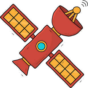
Communications Satellite:- Communication satellites are specially made for Telecommunication. They are used for communication with airplanes, ships, moving vehicles, Handheld satellite phones/devices, Broadcast, TV, Radio, audio/Voice/data/internet communication. They are capable of providing long-distance communication on land, sea, and air. There are two types of communication satellites, as given below: 1. Passive Satellite 2 . Active Satellite 1. Passive satellites are just reflectors or mirrors. They receive signals from the transmitter on Earth and send them back to the receivers at distant places on Earth. Since these satellites do not have any signal-processing units, the signal fades away drastically after traveling a long distance in space from the transmitter on Earth to the satellite and back on Earth. Commercially, passive satellites are not useful. Nowadays, these satellites are not in use for communication, except for some military communication, to minimize illegal interception. 2. To remove the problems of Passive satellites, Active satellites were introduced. Active satellites have onboard processing of signals. Therefore, the satellite performs signal processing and transmits it back to receivers on Earth according to requirements in a better way. Nowadays, such types of satellites find extensive use in communication. |
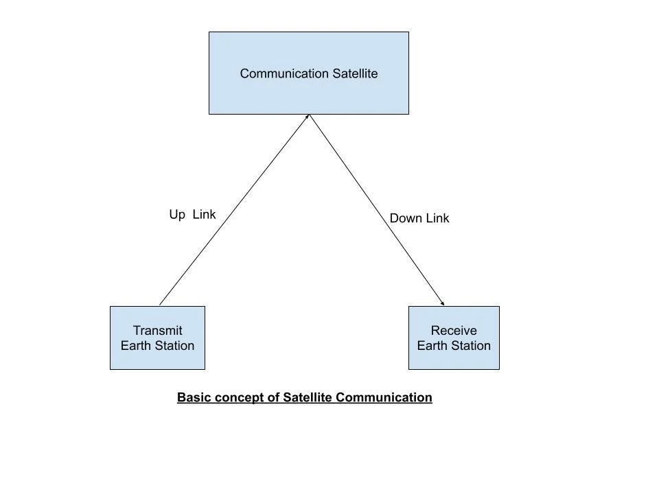
Basic concepts of satellite communication: A communication satellite functions as a remote transmitter and receiver [typically referred to as a transponder {= transmitter + responder (receiver)}]. The rocket projects the satellite into a suitable orbit. It does not fall on earth because it follows the related laws of gravitational force/centrifugal force, physics, and mathematics. A transmitter at an earth station transmits the signals (audio, video, data, etc.) to a satellite. The satellite receives and processes it with the help of a transponder and transmits it back to receivers at earth stations. Electromagnetic Waves are used to transmit the signals from Earth station to the satellite and back. These waves travel at the speed of light (300,000,000 meters/second). The frequency at which earth stations transmit the signal to satellites is called uplink frequency and the frequency at which satellites transmit the signal to earth stations is called downlink frequency. The power supply is continuously needed for the components of the satellite throughout its life. Solar panels provide the power supply for the satellite. Secondary batteries store the electric power from solar panels and provide the same when there is no sunlight. If the receiver end earth station is not within the coverage area of the satellite of the transmitting earth station, the transmitting earth station uses inter-satellite communication to reach the receiving earth station. Note: The earth station is an installation of telecommunication equipment at a particular place on earth. It is directly connected to satellite and terrestrial links to carry out the communication. The Earth station receives the signals from different terrestrial links, and after processing, transmits them to satellites. Similarly, the earth station receives the signal from the satellite and after processing, distributes it to various terrestrial links. However, the satellite connects the signals directly from satellite phones. |
 |
What is a satellite orbit? The satellite orbit is a path followed by the satellite around the Earth. We can classify orbits in different ways based on height from the Earth's surface, the shape of the orbital path, etc. as described below. Classification of orbits based on height (altitude/distance) from the earth's surface: 1. Low Earth Orbit (LEO):- The placement of satellites is around 1000 Km from the earth's surface. ⦁The distance from the earth's surface may be as low as 200 km or as high as 2000 km. ⦁ The orbital period of LEO satellites may be a few minutes to a few hours because of the shorter area covered in one round compared to other orbits. These satellites are changing their position rapidly related to a particular point on Earth. To provide continuous (24x7) communication to cover the whole earth, a group of large numbers of satellites is required in this orbit. This group of satellites is called a constellation. The number of satellites to provide communication on the whole earth will depend on the height of the satellites from the earth's surface and on other requirements. 2. Geostationary Earth Orbit (GEO):- In this orbit, satellites exist at a height (altitude) of roughly 36000 km (exactly 35786 km) from the earth's surface. These satellites are just above the equator and move along the equator (i.e. equatorial plane). GEO satellites take 24 hours to take one round (revolution) of the Earth, just like Earth, which completes 01 rotation along its axis in 24 hours. The movement of the satellites in GEO is similar to the earth's movement direction, i.e. from west to east. Since the Earth and GEO satellites are moving with the same constant speed and same direction, therefore such satellites appear fixed (stationary) related to the Transmitter and Receiver position on Earth. Only 03 GEO satellites (placed 120 degrees apart from each other) are required to provide communication on the whole earth except the polar regions. One satellite roughly covers 40% of the earth's area. GEO satellites cannot provide communication in polar regions because of the flattened structure of the earth near the poles. 3. Medium Earth Orbit (MEO):- The satellites in this orbit exist at a height of around 10,000 km from the earth's surface. This height may be as low as 5000 km and may be as high as 20,000 km. It means that such satellites exist between LEO and GEO. Since such satellites exist between LEO and GEO, their characteristics lie between LEO and GEO. The orbital period of such satellites may be as low as 5 hours or as high as 12 hours.
The number of satellites in this orbit to provide communication on the whole earth will be more than the satellites in GEO and less than the satellites in LEO, depending on the height from the earth's surface. NOTE - Satellites placed in the equatorial plane do not provide communication in the polar regions. However, satellites placed in a polar orbit (moving along the north and south poles) provide communication in polar regions. |
Parameters | LEO | MEO | GEO |
Note - the below parameters are not standard; mentioned to provide a basic idea. | |||
Height from the Earth's surface | 200 km to 2000 km | 5000 km to 20000 km MEOs can be positioned somewhere between LEOs and GEOs, both in terms of their orbit and due to their advantages and disadvantages. | 35786 km or 36000 km approximately |
Orbital period | 2-3 hours | 5-12 hours | 24 hours |
Visibility | Less than an hour | Few hours | 24 hours |
Utility | Mobile & low power communication, etc. | Navigation, GPS (Global Positioning System) etc. | Long-distance communication - Broadcast, TV, Radio, Internet, data communication, etc. |
Coverage area (Footprint) [will explain later] | Hundreds of satellites are required to cover the whole earth. It increases the cost.
| In between MEO and GEO. Dozens of satellites are required to cover the whole earth. | One satellite may cover around 40% of Earth. Only 03 satellites are sufficient to cover the whole earth except the polar regions. One transmitter may provide the signal to millions of receivers due to the largest footprint. |
Delay time {latency} [ will explain later] | Very less (around 10 milliseconds) | In between MEO and GEO | Roughly 240 milliseconds from Earth to satellite and back to Earth. Not suitable for voice communication. |
Projection cost | low | In between MEO and GEO | Very high |
Satellite life | Less than MEO and GEO | In between MEO and GEO | 15-20 years roughly |
Signal loss {free space loss} | Low due to low altitude | moderate | High loss due to large distance {2x36000 km from Transmitting earth station to satellite and back from satellite to Receiving earth station } |
Minimum power requirement at transmitting earth station | very less ( less than 1w) In MEO - | moderate power is required. | Relatively very high which causes problems for battery-powered devices. These satellites cannot be used for small devices/mobile phones. |
What is the difference between a geosynchronous and a geostationary orbit?? The geostationary orbit is a subset of the geosynchronous orbit. All geostationary orbits are necessarily geosynchronous, but all geosynchronous orbits are not geostationary. The below table shows the differences in a better way: |
Parameters | Geosynchronous | Geostationary orbit |
Height from the Earth's surface | 36,000 km, approximately | 36,000 km, approximately |
Inclination Angle | Not necessarily zero-degree | Zero degree, satellite just above the equator |
Direction of movement | Not necessarily west-to-east | Always west to east. |
Orbital period | not necessarily 24 hours | 24 hours |
Orbital path | not necessarily circular | circular |
Latency (delay time): In Geostationary orbit, when signals travel from the transmitting station on earth to the satellite and the satellite to the receiving station on earth will cover 36000(approximately) x 2 = 72000 km distance at the speed of 3x10,000,000 m/s. Therefore it will take 240 milliseconds. Similarly for getting a reply from the other end, it will take 240 milliseconds. In this way, Total 480 milliseconds will be lost to get the reply. This 480 millisecond is called latency or delay time. For voice calls, it is very annoying. Therefore, for voice calls, LEO and MEO satellites are used due to the lesser distance from the earth's surface and thereby lesser latency compared to GEO satellites. Footprint:- It is the area covered by the satellite beam on the earth to retrieve the signal. Satellite beam:- It is the shape made by the satellite signal from the satellite transmit antenna. Its shape depends on the satellite beam width ie. a solid angle made by the signal transmitted back to the earth by a satellite antenna. More beam width angle implies more cover area and a larger footprint. Slant range:- It is the aerial distance (line of sight - LOS) from the earth station to the satellite. Earth coverage angle::- In Geostationary orbit, 03 satellites are sufficient to cover the whole earth except the polar region. To cover effectively, the satellite beam width angle should be around 17.3 degrees, and this angle is called the Earth coverage angle. If this angle is more than 17.3 degrees, Unnecessary overlapping in the coverage area of these 03 satellites will occur and it will reduce the signal strength of the receiving footprint. If this Earth coverage angle is less than 17.3 degrees, 03 satellites will be unable to cover the whole Earth i.e. in some areas, the footprint of the signal will not be available. When we are talking about the whole earth's coverage by the Geostationary satellites, it implies that polar regions are excluded. Look angles:-Look Angles are the combination of 02 angles (Azimuth angle and Elevation angle), which decide the position of the Satellite from the transmitting antenna at the earth's surface. Azimuth Angle:- Draw the imaginary perpendicular from the Satellite to the earth's surface. Make geographical Directions (North, South, East, and West) on a horizontal plane with the center as a transmitting antenna at the earth's surface. Draw the baseline from this center to the foot of the virtual perpendicular drawn from the satellite transmitting antenna. The angle made by Geographical north towards the east with this baseline is called the Azimuth angle. This azimuth angle consists of 360 degrees. If the azimuth angle is 90 degrees, it means on a horizontal earth plane, the satellite is located towards the East. The below table shows the different positions of the Azimuth angle: |
Azimuth angle | 0 degrees or 360 degrees | 90 degrees | 180 degrees | 270 degrees |
Satellite position on Earth's horizontal plane | towards north | towards east | towards south | towards west |
Elevation angle: The elevation angle is the upward angle from the satellite earth station to the Satellite receiving antenna in space. It may be 0 to 90 degrees. However, it should be around 5 degrees to properly target the satellite receiving antenna. Note:- Look angles do not change generally in the case of a Geostationary Satellite, because of the stationary appearance of the satellite. Orbital angle (Orbital slot):- It is measured from 0-degree longitude and varies up to 360 degrees. It tells us the orbital location (position) of the satellite. For example, if the orbital angle of a satellite is 63 degrees east, it means that the satellite is placed 63 degrees toward east from 0-degree longitude. Geostationary orbit has very limited space, only 360 satellites can be accommodated if they are placed 1 degree apart. Satellites cannot be placed less than 0.5 degrees apart to avoid interference between the communication of nearby satellites. Note:- To find out the position of the satellite in space, the look angles and orbital angle are required. |
Classification of orbit based on Inclination Angle:- First, we will define the Inclination angle and then Classify it accordingly. Inclination angle:- It is the angle between the plane of the satellite orbit and the plane of the equator.
The below table gives a good idea of such orbits. |
Classification of orbit based on inclination angle | Equatorial orbit | Polar orbit | Prograde orbit | Retrograde orbit |
Inclination angle | 0 degrees or 180 degrees | 90 degrees | Varies from 0 to 90 degrees | Varies from 90 to 180 degrees. |
Classification of orbit based on eccentricity:- Eccentricity is a mathematical term, which describes the shape of an orbit. If the eccentricity is 0, it means that the shape of the orbit is circular, and if the eccentricity lies between 0 and 1, the orbit is elliptical. If the value of eccentricity is near to 0, it means, the shape is near to the circle, and if the value of eccentricity is near to 1, it means, the shape of the orbit is highly elliptical. On this basis, Satellites exist in Circular and Highly Elliptical Orbit (HEO). Most of the satellites are working in circular orbit. Only a few satellites are working in HEO. HEO satellites provide various services including communication in polar regions. Due to the elliptical shape of the orbit, the satellite's distance from the earth varies from 1000 km (approximately) to 40000 km (approximately) Note:- In addition to the above classifications, other types of orbits also exist. Some are mentioned below: Semi Synchronous orbit - at a height of roughly 20000 km from the earth's surface.
Geostationary Transfer Orbit (GTO) - Due to the very high distance (36000 km) of Geostationary orbit from the earth's surface, we place the Geostationary satellites in two parts. Initially, satellites are placed in GTO, roughly 20000 km from the earth's surface with the help of a rocket, and then an engine fitted in the satellite is fired to place the satellite finally in the Geostationary orbit. High Altitude Platform (HAP) - may exist as low as 50 km from the earth's surface. Graveyard orbit - The Geostationary Satellites which are nonfunctional are forced to be placed at a higher height (above 40000 km approximately) from the earth's surface. This new orbit is called the Graveyard orbit. Geostationary orbit has a very limited capacity (around 700 satellites) to place the satellites. By putting nonfunctional satellites into Graveyard orbit, Geostationary orbit provides the space for new satellites. Disclaimer - The best efforts are made to provide the correct pieces of information in this article and it is for educational purposes only. However, the author does not take any responsibility/guarantee for its correctness. |
Conclusion:- Basic concepts of satellite communication are explained here for beginners. However, we have to go further into deep study for interesting aspirants. Readers are requested to share their inquiries to get more updates and material on the subject. |
===The END===
- Get link
- X
- Other Apps


Comments
Post a Comment
Thank you, most welcome, 👍